Monday, November 30, 2020


POST #21-10

Exploring The Volcanic Field

Subscribe to our Blog! 

Get E-Mail notifications about new posts!

Fill the CONTACT US TO SUBSCRIBE fields!

********

Tap any photo or video to enlarge/play.

Tap any underlined links to follow. 

********

Today, November 30th, we drove the 10 miles back north from our campsite at the Flagstaff KOA to the Sunset Peak Volcanic Fieldan area of volcanoes just north of Flagstaff. The field covers 1,800 square miles of the southern boundary of the Colorado Plateau, and contains 600 volcanoes ranging in age from nearly 6 million years old to less than 1,000 years, of which Sunset Crater is the youngest. The highest peak in the field is Humphreys Peak, Arizona's highest at 12,633 feet and is a part of the San Francisco Peaks, an extinct stratovolcano complex.


The San Francisco Peaks are the remains of an eroded stratovolcano.  Prior to its collapse due to a lateral eruption (similar to the Mount St. Helens eruption in 1980) to the northeast (around 200,000 years ago) and subsequent glacial erosion, the San Francisco Peaks is estimated to have been around 16,000 feet.  You can visualize the original mountain by continuing the line of the west and east sides of the peaks to where the lines meet on the above photo.  It's easy to see where the mountain blew out in this graphic...


We then drove on through the Volcanic Cinder Cones towards Sunset Crater.  On the way we passed the Bonita Lava Flow.  This lava flow, shown below, erupted from the west base of the cone. The absence of cinders on the flow suggests this occurred late in the eruptive life of Sunset Crater.  All of the hills seen in the background are more Cinder Cones. Watch this short video of a lava flow.  You can see how it looks identical to what we see here! (sorry about CNN😒)


We carefully picked our way into the flow...


You could easily damage yourself trying to walk around in this jumble of lava...


Here is a sign to help explain Lava Flows...Sorry about the shadow...


Here is where the lava flow came out of the base of the Sunset Crater Cinder Cone...The lava flow appears very recent...the plants are just now starting to take hold after 1000 years!  Sunset Peak in the background...


Here's a great aerial photo showing Sunset Peak and surrounding cinder cones and lava flows...


Here is a short clip from the 1969 movie "Easy Rider" where they are riding through the area!  I've watched that movie many times but never made the connection till I watched it again a couple nights ago!


We walked a bit up the side of the hill you see in the lower right of the photo above.  It's a loose gritty coarse sand like I have seen in photos of the Marine landing at Iwo Jima during WWII.  I wanted to get a feeling of what it was like when my Dad came ashore there on Iwo, trying to climb that loose grit.  Imagine climbing a steep hill like that with a heavy gear and your gun while under fire from above!!  It was very difficult to climb that hill!!

By the time we were finished exploring the Volcano Area it was nearly sundown.  We headed back to the KOA for dinner and to prepare for heading out in the morning to continue south...

Until Next Time!


Sunday, November 29, 2020


POST #21-9

Flagstaff...Cold Country....Volcanos

Subscribe to our Blog! 

Get E-Mail notifications about new posts!

Fill the CONTACT US TO SUBSCRIBE fields!

********

Tap any photo or video to enlarge/play.

Tap any underlined links to follow. 

********

Today, November 29th, we left the Lee's Ferry Campground and headed south.  We will miss this place!  The weather is clear, about 40 degrees and light wind. Our destination today is Flagstaff, AZ and the KOA Campground..not too far...123 miles...


A sped up video of most of the drive can be found HERE.  On this drive we go up from a desert type landscape to a Ponderosa Pine forest area.  Towards the end of the drive we go through a Volcanic area.  


The San Francisco Peaks are on the right in the video.  The San Francisco Peaks are a remnant of the former San Francisco Mountain.


The highest summit in the range, Humphreys Peak, is the highest point in the state of Arizona at 12,633 feet. The San Francisco Peaks are the remains of an eroded stratovolcano.  Prior to its collapse due to a lateral eruption (similar to the Mount St. Helens eruption in 1980) to the northeast (around 200,000 years ago) and subsequent glacial erosion, the San Francisco Peaks is estimated to have been around 16,000 feet.  You can visualize the original mountain by continuing the line of the west and east sides of the peaks to where the lines meet on the above photo.  It's easy to see where the mountain blew out in this graphic...


On the left side is a field of Volcanic Cinder Cones and Lava FlowsThe youngest cinder Cone in this field is the Sunset Crater Volcano...


This Cinder Cone, is estimated to be less than 1000 years old and is about 1120 feet high.  Given that Sunset Crater is such a young volcanic feature of this area and that eruptions have occurred every several thousands of years, it is likely that there will be a future eruption in the San Francisco Volcanic field. However, it is impossible to predict when and exactly where a new eruption might occur.  Again, a sped up video of most of the drive can be found HERE.

We pulled into the Flagstaff KOA about 3:30 PM.  It's a nice campground but kind of a letdown after where we just left.  We plan to stay here two nights, to do laundry, restock the pantry and use their electricity to help stay warm.  They are expecting temps in the low 20's to the mid teens so we will need it!  We will be going back the 10 miles tomorrow to better explore the Sunset Crater Volcanic area!

Until Next Time!


 POST #21-8

The Old Lee's Ferry Ghost Town....

Subscribe to our Blog! 

Get E-Mail notifications about new posts!

Fill the CONTACT US TO SUBSCRIBE fields!

********

Tap any photo or video to enlarge/play.

Tap any underlined links to follow. 

********

Today, November 28th, we drove over and checked out the old buildings and mining equipment at the actual site of the Lee's Ferry.  This is the only place within Glen Canyon where visitors can drive to the Colorado River in over 700 miles of canyon country, right up to the first rapid in the Grand Canyon. Lee's Ferry was important in the exploration and settlement of northern Arizona, as a natural corridor between Utah and Arizona.  Here are some historic photos...


Charles H. Spencer came with his American Placer Corporation in 1910 and set up operations at Lee’s Ferry... 


He hoped to use high pressure hoses utilizing water pumped from the river to sluice the gold from the Chinle shale, sending that sluiced material by flume to an amalgamator set up to attempt to remove the gold. This historic photo shows a boiler used by Spencer, in a failed try at gold mining from 1910-1912, at Lee's Ferry....


The remains of the boiler today...


And the remains of the steam engine that was fed by that boiler...

Spencer even built a steamboat, dubbed the “Charles H. Spencer,” to transport coal along the river as fuel for his equipment. The boat, designed for much tamer rivers was not very successful in navigating the more powerful Colorado and was eventually beached and never operated again, succumbing to the unforgiving river over the years...


This is all that's left of the steamer...


This is what's left of Spencer's old office...


The Mormon church built what became known as Lee’s Fort in 1874, and it still stands today. The building served as a home, trading post and school for ferry operators’ families.

Here's all that's left of the fort today...


Then we went a short distance to the Lonely Dell Ranch....John D. Lee, for whom the Ferry is named, was a practicing polygamist who built cabins for two of his families at Lees Ferry. His wife Emma named the ranch at Lees Ferry "Lonely Dell" due to its austere remoteness.  In 1877 Lee was executed for his role in the Mountain Meadows massacre. In 1879, the LDS Church bought the ferry rights from Emma Lee, granting the ferry service to Warren Marshall Johnson and his families. A number of structures remain from the ranch from the polygamist period of the Lee and Johnson families.  This is the entryway to Lonely Dell Ranch, where the ferrymen's families lived and farmed during the ferry's heyday...


Some old buildings at the Lonely Dell Ranch....


The LDS Church eventually sold the property and it wen through several owners until it was purchased by the National Park Service in the '60s...The original orchard was restored by the NPS and they maintain the old buildings..  You can harvest various fruit and nuts from the orchard when it is producing!


Today Lee's Ferry is officially Mile Zero where the rafting trips down the Grand Canyon begin, for a weeklong trip down the Colorado River...A lot of boats were leaving the while time we were here.  That would be quite the adventure!


This was an interesting day of exploring!  And our last day here at the Lee's Ferry area.   Tomorrow we head further south...Destination Flagstaff, AZ...

Until Next Time!


Friday, November 27, 2020


 POST #21-7

Exploring The Lee's Ferry Vicinity....

Subscribe to our Blog! 

Get E-Mail notifications about new posts!

Fill the CONTACT US TO SUBSCRIBE fields!

********

Tap any photo or video to enlarge/play.

Tap any underlined links to follow. 

********

Today, November 27th, we drove around and looked at interesting things nearby...There was a field of these balancing rocks...


An inset from the sign.....


Then we drove over to the Navajo Bridge over the Colorado River, just a short distance downstream from our campsite.  


Prior to completion of the first Navajo Bridge in 1928, one of the only Colorado River crossings between Arizona and Utah was located about 5 miles  upstream from the bridge site, at the mouth of Glen Canyon where Lees Ferry service had operated since 1873. That is right where we are camped.  The ferry site had been chosen as the only relatively easy access to the river for both northbound and southbound travelers. By the 1920s, automobile traffic began using the ferry service though it was not considered a safe and reliable crossing as adverse weather and flooding regularly prevented its operation.  Read somewhere at the end of the Lee's Ferry service the last crossing was with a Model "T" on board...the ferry capsized and the car, its occupants and the ferry pilot all drowned. The The newer bridge, finished in  1995, replaces the obsolete narrow bridge.  The old bridge is now used as a walkway for tourism.  Both are 470 feet above the water.  There is a sign that says "no jumping from bridge"...OK no problem!  This is an upstream view from the old bridge...


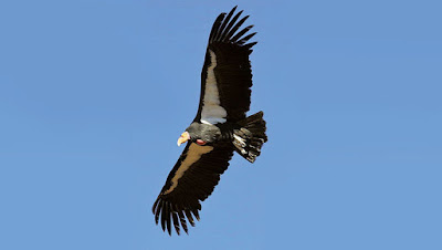
When we were on the old bridge we saw some California Condors roosting under the new bridge....


Had to zoom way in so the photos are not too clear...

Its 9 ft wingspan is the widest of any North American bird, and its weight is up to 26 lbs. The condor is a scavenger and eats large amounts of carrion. It is one of the world's longest-living birds, with a lifespan of up to 60 years.  Then one flew in...


We never expected to be able to see any of these birds...they nearly went extinct.  They were down to only 27 known birds.  These surviving birds were bred at the San Diego Wild Animal Park and the Los Angeles Zoo. Numbers rose through captive breeding and, beginning in 1991, condors were reintroduced into the wild. Since then, its population has grown, but the California condor remains one of the world's rarest bird species: as of 2019 there are 518 California condors living wild or in captivity.  It was cool to see them!

Tomorrow is our last day here at the Lees Ferry Campground.  We will explore some old buildings down by the river at the old ferry site...

Until Next Time!


Thursday, November 26, 2020


POST #21-6

The Spectacular Lee's Ferry Area On The Colorado 

Subscribe to our Blog! 

Get E-Mail notifications about new posts!

Fill the CONTACT US TO SUBSCRIBE fields!

********

Tap any photo or video to enlarge/play.

Tap any underlined links to follow. 

********

On November 24th we arrived at the Lee's Ferry Campground at the start of the Grand Canyon.  Spectacular views, very quiet and only $10 per night with our old folks national discount.  We are here for 5 nights.  No hookups, but water is nearby.  We filled up with water when we arrived and refilled once with our portable water bladder. We got to try out our new Lithium Battery System and solar panels.  We were able to go 3 days without having to top up the battery with the generator...It probably would go more time, but held a steady 13.5 volts the whole time.  Lithium batteries are great...they have twice the capacity of regular batteries but are half the weight!  

This place is a good discovery...so scenic!...


Not overly warm!  Mid-50s daytime, upper 20's at night.  But sunny! Love sunny!


There will be a full moon while we're here!


There it is!  The cameras on these phones take great low light shots!  


We will be exploring this area and will report back what we find!

HAPPY THANKSGIVING TO ALL!!

Until Next Time!


Wednesday, November 25, 2020


POST #21-5

 Into The Grand Canyon....

Subscribe to our Blog! 

Get E-Mail notifications about new posts!

Fill the CONTACT US TO SUBSCRIBE fields!

********

Tap any photo or video to enlarge/play.

Tap any underlined links to follow. 

********

After four super quiet, but chilly nights at the Kaibab, AZ Paiute Indian RV Campground we headed out November 24th to a new spot we found online...They were very friendly Paiute Indian people running the park, and some traditional Mormon helpers.  Pipe Spring National Monument is right across the road...For thousands of years, native people, plants and animals have relied on the Pipe Spring for its life-giving water. Beginning in the 1850s, members of the Church of Jesus Christ of Latter-Day Saints began to settle the area the Kaibab Paiute called home. The new settlers drastically altered the landscape and set the stage for conflict and compromise on the western frontier.  Unfortunately the visitor center was closed due to "Rona" so we didn't visit.

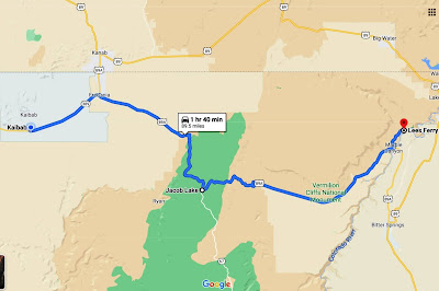
Anyway we headed out and traveled east and south towards Page, AZ.  Destination Lees's Ferry Campground....A distance of about 90 miles.  It was clear...not a cloud in the sky! We assumed we were in for an easy drive...


But as we came closer to this part we began seeing vehicles with 6 inches of snow on top coming down the hill on the road we were going up... Jacob Lake  is at about 8,000 feet in a large ponderosa pine forest which is part of the Kaibab National Forest.


A sped-up video of us crossing that pass can be seen HERE...watch for the truck mishap near the top...Our vehicles got covered with salty slush...It was a mess!!

After we came off of the pass we descended into wide open spectacular country...


We dropped into Marble Canyon and then further down into what is the beginning of the Grand Canyon.  Another sped-up video of us coming off of that pass and into the Vermillion Cliffs, the canyon area and pulling into our campsite at Lee's Ferry Campground can be seen HERE.  We scored a wonderful site at the bottom of the loop overlooking the Colorado River!  We pulled in about 1 pm and had camp all set up by 2...That's us up there!  


Went to the Boat Ramp with each vehicle to wash the slush off and fill the motorhome with water.   Then we were able to relax and take it all in!


We will be staying here for several days!  More Pix and info to come!

Until Next Time!