POST #21-31
A Hike Into The Superstitions..
...A short one anyway...
Subscribe to our Blog!
Get E-Mail notifications about new posts!
Fill the CONTACT US TO SUBSCRIBE fields!
********
Tap any photo or video to enlarge/play.
Tap any underlined links to follow.
On February 9th I decided to take a hike up a ways into the Superstition Mountains on the Siphon Draw Trail while camping at Lost Dutchman State Park. The Siphon Draw Trail link has a lot of great info and photos!
That's a 5.5 mile there and back hike with an elevation gain of 2641 feet. I walked up about 1.4 miles (the line roughly follows the trail). I packed Sparky the Drone up there to see if I could fly in the safe zone between the park boundary and the wilderness boundary.
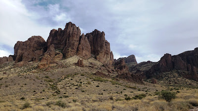
I got as far as the big pointed rock that's on the right side of the photo...
It was getting late, the trail was getting very rough and steep and there was a long way to go to the Flatiron.
Every evening we could see folks descending the trail, in the dark, with flashlights, but...Think I will pass on that one! Found some interesting signs along the way...
Came across this old concrete work along the trail...I imagine it's the remains of old abandoned gold mining works...
Stopped and used the flat piece for a drone launch pad and got this video... The video is sped up 3X. The drone was set in "Sport Mode" which is very fast. It took a long time to get up there and it couldn't stay long cuz the battery went fast in that mode! Tap the arrow on the video to play.
As I crossed the Wilderness boundary the terrain got rougher and the rocks, boulders and monoliths got bigger...
Took a video with my phone from this area...tap arrow to play...
Looking back down...and sunset!
By the time I made it back it was almost dark and the stars were starting to show...


I hope I can hike with you there. Maybe we will come for a visit next year!
ReplyDelete